Participatory mapping has proven to be effective in generating the diversity of how different local communities view disasters, vulnerabilities, and other concepts related to DRR.
Emmanuel Garcia, “Of Disasters and Participation”, 2021
Maps started out from the graphic representation of the earth. They were (and continue to be) rendered as 2-D maps as a convenient reference guide when one is figuring out a way from the labyrinth that characterise strange and unfamiliar landscapes.
Cartographic outputs blossomed through the decades to resist the 2-dimensionality of maps to show a more complete picture of the lay of the land. Too, the creation of maps is no longer confined to cartography laboratories under the auspices of academic institutions and professional organisations. People have been consulted to put local knowledge front and center in any representation of landscapes, waterscapes, peoplescapes and others.
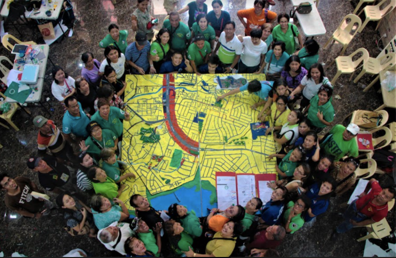
Of the wide array of participatory and community-based mapping activities that are currently being done in the field, Participatory 3-Dimensional Mapping (P3DM) stands out because of its ability to fuse scientific and local knowledge which is very important particularly in the field of disaster risk reduction (DRR). P3DM is a multi-sectoral and community-based mapping activity that creates a stand-alone, geo-referenced and scaled model of a certain area showcasing thematic layers of geographic information (Rambaldi & Callosa-Tarr 2002; Cadag and Gaillard 2012; Garcia 2021). In short, it is the process of making a 3-dimensional map of a given area display community-identified information that places importance on local knowledge (Map 1).

Map 1: Digitized P3DM in Brgy. Dalnac, Paracale, Camarines Norte. PGS CPAG DRR Team, 2017
P3DM was first used for natural resource management, however, its usefulness transcended the field of DRR. Typically, a P3DM for DRR has the following information (Map 2).
- General topography
- Actual land uses
- Critical infrastructures
- Housing structures
- Vulnerabilities
- Capacities
- Hazards

In Map 2, the colored paints represent specific land uses following the standard colors used for land use planning as prescribed by the DSHUD; the pushpins represent housing structure which are color-coded (red for light materials; blue for semi-concrete; and green for concrete) to highlight construction materials; the different pins represent critical infrastuctures while the other pins represent community-identified vulnerabilities and capacities; and finally the yarns represent the type of hazard affecting the specific area of the community.
The Philippine Geographical Society (PGS) has been doing P3DM activities since 2015 through collaborations with various organizations. It partnered with UNICEF in assisting partnered Civil Society Organizations (CSOs) in their child-centered approach to DRR. On the other hand, Philippine Disaster Resilience Foundation (PDRF) has been a strong ally in implementing P3DM in urban areas such as Quezon City and Makati City. Through these engagements, P3DM proved to be a useful methodological tool for engaging local knowledge and evoking community and multi-stakeholder participation in DRR planning.
To know more about PGS and the group’s undertakings, check out the PGS website or email philippinegeographicalsociety@gmail.com.
Aside from PGS, the UP Department of Geography through its yearly fieldschool (Geography 192) is engaged with P3DM and the creation of ecological profiles as a way to serve communities.
JS Palis, EB Garcia & JR Cadag
January 15, 2024
References
Cadag, J.R.D. and J.C. Gaillard (2012). Integrating knowledge and actions in disaster risk reduction: The contribution of participatory mapping. Area 44(1): 100-109.
Garcia, E. (2021). Of Disasters and Participation: Situating Local Knowledge in Disaster Risk Reduction and Management (DRRM) through Participatory 3-Dimensional Mapping (P3DM). The Pennsylvania Geographer 59.2. 32-50.
Rambaldi, G. and J. Callosa-Tarr (2002). Participatory 3-dimensional modelling: guiding principles and applications. ASEAN Regional Center for Biodiversity Conservation (ARCBC), Los Baños, Philippines.

Leave a comment